A World Without Maps
October 31, 2013 Leave a comment
A World Without Maps
MELIK KAYLAN
Oct. 29, 2013 4:42 p.m. ET
Measuring and Mapping Space: Geographic Knowledge in Greco-Roman Antiquity
Institute for the Study Of the Ancient World
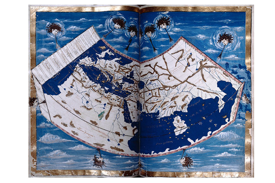
Ptolemy’s Earth, from a Florentine manuscript (c. 1460). New York Public Library
The contradiction may seem insuperable—that the main point of an exhibition about ancient maps is that there weren’t any, or any that have survived. But don’t let that put you off. The show at the Institute for the Study of the Ancient World (ISAW) is titled “Measuring and Mapping Space: Geographic Knowledge in Greco-Roman Antiquity.” Its explanatory circular tells of focusing on “ancient cartography and the ways in which Greek and Roman societies perceived and represented both the known and unknown worlds.” All of which certainly suggests that you will see maps. And you will, but not what you expect.Many of us may have a vague sense that we knew of such maps, indeed that we have a distinct memory of what they looked like, scrawled on hide or parchment or somesuch. It turns out we were wrong. Or rather that we were semideceived into forming such memories by the imaginings of scholars who lived a millennium or more after the classical era ended. In effect, the Medieval world invented the idea of the ancient map.
This little gem of a show delivers quite a few startling challenges to our assumptions and is worth the visit for the mental rearranging it asks of us. More than 40 objects, some of them facsimiles, are divided into five sections: “Mapping the World,” “Measuring the World,” “Roman Geography and Politics,” “Secular and Divine Geography” and “Peripheries and Imaginary Geography.” All the artifacts come from prominent U.S. institutions, mostly in New York, including the Morgan Library & Museum, the New York Public Library and the Metropolitan Museum of Art. There’s also an ancillary room with a digital presentation and the photo-facsimile of a horizontal Roman-era map (the original sits in an Austrian museum), which depicts the empire’s road-lines. It’s the only one of its kind that has survived. It isn’t exactly a map—but, rather, a decorative illustration of Roman power with Rome at the center.
Why do we have virtually no ancient maps of the ancient world? After all, sailors, traders and soldiers had to find their way around. The show’s curator, Roberta Casagrande-Kim, distinguishes between a map and an itinerary. The latter “must have existed aplenty, but being strictly functional probably deteriorated through overuse,” she says. A map, however small its focus, suggests a kind of implicit overview, and that is the show’s subject.
We learn, first and foremost, that the ancient world’s notion of the globe came together in Ptolemy’s “Geographia,” a written (not drawn) second-century description of the globe as it was then known. Ptolemy’s work itself articulated a largely Greco-Roman conception from Aristotle and Strabo onward of where things lay. His manuscripts were rediscovered and translated into Arabic in the Middle Ages and then traveled to Europe, in Latin translations, during the early Renaissance. Upon entering the main room, you see large medieval folios that reconstructed the macro-order of things from Ptolemy’s original. For a great swath of history, much of humankind believed this was the world it went to sleep and woke up in. The Earth, at the center of the universe, radiated a concentric order of things, including the motion of the stars. This is what Galileo was up against.
In that first section, we encounter the show’s pièce de resistance. Lent by the New York Public Library, it’s a world map from a Florentine manuscript (c. 1460) that meticulously visualizes Ptolemy’s Earth. America, Australia and the polar continents simply didn’t exist. Northern reaches of Asia and southern Africa faded into blank space where, as we see depicted in a later section, semimythical creatures roamed. According to the curator, knowledge had expanded hugely by 1460, and the book’s author surely knew it, but he stuck to second-century norms as a matter of faith. The fact is, both the ancients and pre-Galileo Medievalists equated geography with divine order, geophysics with metaphysics, and simply didn’t see the need to connect “itineraries” with map concepts. None of which affected the Roman penchant for precise measurement and engineering. We see the measuring tradition alive and well in surveyors’ codexes from the sixth century showing city grids.
In the “Divine Geography” section we see how Christianity adopted the globe-views of antiquity, while adding its own schematized layers—for example of Cherubim and Seraphim populating the heavens (the kind of codification emulated by Dante). These images were a symbol of continuity and of power—of the faith’s dominion in sync with the eternal verities through space and time. Roman coins, all on loan from the American Numismatic Society, showing emperors standing atop globes demonstrate the idea’s origins—you held sway over the mortal world as intended by the immortal gods. Heavenly and earthly power were synonymous, part of a complete order. The correct way of encompassing that order through physical and metaphysical schematics, such as maps, gave the gods their due and accorded humankind a stable place in their plan.
The real trouble began when empiricism discovered—and, worse, began to depict—a detached world, one that followed its own laws and required its own maps. But the show’s timeline stops at that Earth-changing juncture.
In the ancillary room, you see a digital quantum leap in the history of mapping the ancient world. It’s a complex achievement, and visitors should spend time fathoming it in situ. But briefly put, ISAW has developed software (with others) that collects all available information on ancient sites. The information comes from institutions world-wide, such as museums, colleges and publications. Whether it exalts or buries the gods further, only time will tell.

